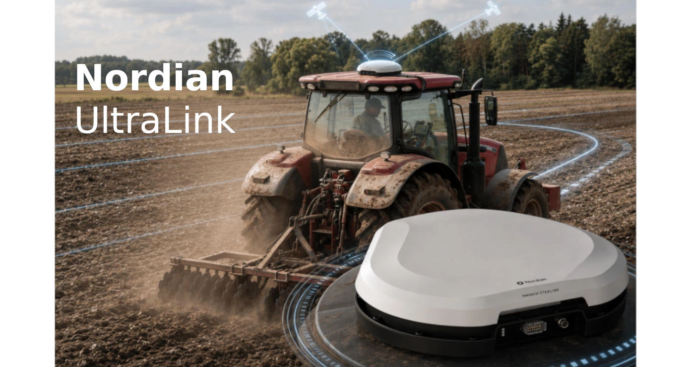
Nordian Technologies to Enable Precise Agricultural Machinery Navigation via Starlink and GNSS
Satellite internet, high-precision GNSS receivers and correction services are gradually changing the very logic of navigation in precision agriculture. While centimetre-level accuracy used to be associated mainly with local RTK base stations, radio links and complex field infrastructure, a new generation of solutions such as the Nordian UltraLink platform focuses on a different approach: transmitting correction data via satellite communication and maintaining stable navigation even where mobile networks are unreliable or completely unavailable.
According to Future Farming, Nordian has introduced the UltraLink platform, which combines Starlink satellite connectivity with high-precision GNSS positioning. Its purpose is to simplify access to RTK-level accuracy for agricultural machines, including those operating in remote regions without reliable mobile internet coverage. At the same time, Nordian’s official product materials confirm the core technical foundation behind this approach: multi-frequency GNSS solutions, correction data support, satellite telemetry, IMU integration and centimetre-level positioning accuracy.
Why This Is More Than Just “GPS Navigation” for Agricultural Machinery
In today’s field operations, a tractor, sprayer, seeding complex or autonomous robot must do more than simply “know” where it is. The machine must hold a stable trajectory, repeat passes, work between crop rows, apply materials accurately and avoid losing orientation during turns, manoeuvres or short-term signal disruptions.
That is why a standard GNSS signal is often not enough for precision agriculture. Autosteer systems, inter-row cultivation, precision spraying and robotic platforms require real-time position correction. In the traditional setup, this is provided by an RTK base station or network NTRIP corrections transmitted via the internet. But this creates a practical problem: large agricultural areas are often located exactly where mobile network coverage is unstable.
The logic of UltraLink, when viewed through the announced Starlink integration and Nordian’s verified GNSS solutions, is to break this dependence on terrestrial mobile communication. Satellite internet can serve as a channel for transmitting correction data, while the GNSS receiver and sensor block on the machine convert that data into precise field navigation.
The Technical Foundation Behind Nordian
In Nordian’s product line, the Ultra and Ultra+ high-precision receivers and smart antennas play a central role. For the Ultra Smart Antenna, the manufacturer states horizontal accuracy of 0.03 m RMS, pass-to-pass accuracy of 0.02 m, position acquisition in under 40 seconds, support for GPS, GLONASS, Galileo, BeiDou, QZSS and SBAS, as well as operation on L1, L2, L5 and L6 frequencies, including E6/B3.
It is also important that Ultra is not limited to GNSS reception alone. The system uses an integrated 6-axis IMU: a gyroscope with a range of ±2000 degrees per second and an accelerometer with a range of ±16 g. The update rate is 50 Hz when GNSS is combined with IMU Sensor Fusion. For agricultural machinery, this has direct practical value: the machine is not operating on a perfectly flat laboratory surface, but in a field with slopes, tracks, uneven ground, vibration and sharp changes of direction.
The higher-end Ultra+ Smart Antenna is aimed at even more demanding applications. For this model, Nordian states horizontal accuracy of 0.01 m RMS, pass-to-pass accuracy of 0.01 m and RTK convergence time of under 10 seconds. The specifications also list correction sources: RTK bases, L-Band and NTRIP. This is an important detail because it points not to a single closed operating scheme, but to a flexible architecture that can be adapted to different regions, farm types and available infrastructure.
Starlink as the Communication Channel, GNSS as the Accuracy Foundation
In this technology, Starlink does not replace GNSS. These are fundamentally different elements. GNSS is responsible for determining coordinates, while Starlink can serve as the communication channel for transmitting correction data, telemetry, diagnostics or remote service management. This combination is especially relevant for agriculture: the machine receives coordinates from satellite navigation systems, while corrections and service data can be transmitted via satellite internet where mobile networks are unavailable.
In its official materials, Nordian also highlights the possibility of two-way satellite communication for telemetry in areas without cellular or internet coverage. For Ultra and Ultra+, the manufacturer describes satellite telemetry as a way to transmit diagnostics and status messages in zones where mobile communication is unavailable.
For farmers, this is not just a matter of convenience. If machinery operates across large areas, remote fields or regions with weak telecommunications infrastructure, a stable communication channel can be critical. Without it, an autosteer system or robotic platform may lose positioning quality, while the operator may lose real-time control over the system.
Correction Services: NTRIP, L-Band and PPP-RTK
Nordian is developing not only the hardware side, but also correction services. On the UltraPoint page, the company describes a PPP-RTK GNSS augmentation data service with 2.5 cm RMS accuracy within seconds. The service is stated to be available via mobile internet or L-Band satellite signal, with convergence time of less than 30 seconds for centimetre-level accuracy.
Nordian also offers an NTRIP service for transmitting GNSS corrections via the internet. This is important for farms that already have stable connectivity and want to receive network RTK corrections without deploying a local base station. However, in scenarios where internet connectivity in the field is unstable, satellite communication becomes a logical addition to the classic NTRIP model.
As a result, a multi-layer system is formed: the GNSS receiver determines the position, the IMU stabilises navigation during movement and manoeuvres, the correction service improves accuracy, and satellite communication helps deliver data to places where terrestrial networks cannot cope.
What This Means for Tractors, Sprayers and Robots
For tractors, this technology means more stable guidance lines, fewer overlaps and skips, and better repeatability of operations between seasons. For sprayers, it means more precise trajectory control and potentially more accurate application of crop protection products. For seeding units, it supports control over passes, row spacing and repeatable movement. For robotic platforms, it opens the possibility of operating without constant dependence on local RTK infrastructure.
Nordian’s official case study with Hural shows that this approach is already being used in agricultural robotics. In that example, a robotic platform achieved centimetre-level accuracy and stable heading data without traditional RTK infrastructure. The solution used a u-blox ZED-F9P GNSS module via a Nordian OEM board, support for PPP-RTK and RTK corrections, and PointPerfect Flex via L-Band and IP.
The use of two integrated smart antennas on each robot is particularly revealing. According to Nordian, this configuration provides not only accurate positioning, but also reliable heading data - meaning the machine’s orientation relative to its direction of travel or true north. For autonomous machines, this is critical: a robot must understand not only its point on the map, but also its own orientation in space.
Practical Value for the Agricultural Market
The main value of such solutions is not in the attractive formula “Starlink plus GNSS”, but in reducing the infrastructure barrier. A traditional RTK setup often requires base stations, radio coverage, configuration, service support and a stable data transmission channel. For large agricultural holdings, this is manageable; for medium-sized farms or manufacturers of autonomous equipment, scaling can be much more difficult.
If corrections can be received via IP, L-Band or satellite channel, and the equipment supports plug-and-play integration, CAN, serial ports, NMEA, RTCM and other industrial interfaces, machinery manufacturers can integrate the system more easily into a tractor, robot, sprayer or specialised platform. For Ultra+, Nordian directly specifies support for NMEA 0183, NMEA 2000 and RTCM, as well as CAN bus, PPS, GSO and UHF Radio.
For agriculture, this may signal a transition from “precision farming only where infrastructure exists” to a model in which accuracy becomes more accessible for remote fields. This is especially relevant for countries and regions with large land areas, uneven mobile coverage and growing interest in autonomous machinery.
The news about UltraLink is important because it points to a broader trend: agricultural navigation is moving from local infrastructure toward hybrid cloud-satellite models. In this scheme, Starlink can serve as the communication channel, GNSS as the coordinate source, RTK/PPP-RTK corrections as the accuracy improvement mechanism, and IMU with sensor fusion as the way to stabilise machine movement in real field conditions.
At the same time, it is important to distinguish between the confirmed specifications of Nordian’s products and the media wording around UltraLink. Nordian’s official pages confirm centimetre-level accuracy, multi-frequency GNSS, IMU, satellite telemetry, and support for NTRIP, L-Band and RTK corrections. The announced integration with Starlink primarily describes a new way of delivering communication and correction data to machinery operating far from stable terrestrial networks.
For the agricultural sector, this could become one of those technological steps that quietly change everyday field work: less dependence on coverage, faster deployment, more precise passes, more stable operation of robotic platforms and a more realistic path toward autonomous farming across large areas.
Add a comment
Comments
There are no comments yet. Be the first to comment.
You must be logged in to post a comment
Login